Other Maps
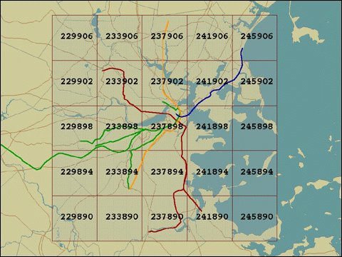
This map shows the city of Boston and surrounding cities, major roads and local subway lines. It is used for selecting tile grid numbers associated with the image filename from the appropriate directory.
The structure of the filename for selecting 1 meter per pixel ortho photos is as follows: 1-"quad number".tif. For example, if you want to view the photo for the quad in the middle, 237898, then the filename you will look for is: "core/ortho_1m/1-237898.tif"
For those of you who may not speak this language this means to look on the directory named 'core' within his archive. There you will find a directory or folder called "ortho_1m." In that directory you will find the file you are looking for: 1-237898.tif.
If you need to select a 2 meters per per pixel image, then you will just substitute the prefix of "1" for the prefix of "2." Your new filename for the same tile in a 2 meters per pixel resolution would be, "2-237898.tif."
If you need to select a USGS scanned map image, then the only structure of the filename that changes will be the prefix. Instead of using a "1" or "2" you will use a "Q." The USGS maps only come in one resolution so you do not have to define what scale of image you desire.